“Sa Calobra” – “The Snake”, in Catalan
Spain is a very young country, with a long and tortuous history. Two millennia ago, the Roman Empire consolidated the Iberian Peninsula, building an extensive road network, many of their famous amphitheaters, and leaving behind various iterations of Latin in the modern day languages of Catalan, Majorcan, Castilian, and Portuguese. Vandals from North Africa (a real people) picked at the carcass as the Empire disintegrated, only to give way to a Muslim invasion (the Moors) as the Prophet Mohammed’s warriors swept up from the Magreb.
Christians went into hiding. Many converted, but the Church of Rome kept its candles burning, and, in the early 13th century, 20-year old James I began the re-conquest of Spain, which took over 200 years to complete.
Throughout all the back and forth, the idyllic Balearic Islands in the eastern Mediterranean, southeast to Barcelona, remained part of the Spanish domain. Mallorca (aka Majorca, the biggest, or “major” island), was the last part of Spain to come under the fascist rule of Francisco Franco. Along with the rest of Spain, the islands emerged as a modern democracy only after Franco’s death, in 1975.
After World War II, Northern Europeans – British, Low Countries, Germans, Nordic – discovered the joys of travel, especially to escape the dreariness of early Spring. As a limestone upthrust island (not volcanic), the terrain is varied and striking. Numerous bays enclose placid turquoise Mediterranean waters. Rugged mountains define the entire north coast, rising to 4700’, enough to create their own weather. The central plains, with a year-round growing season, are ideal for agriculture, especially olive trees.
Mallorca is not as large as, say, Sicily, Sardinia, or Corsica. It is about the size of Rhode Island (if Narragansett Bay is included), while its population is a touch smaller. In contrast, Hawaii’s Big Island is nearly three times as large, with 1/5th the population. But, given its status as a prime playground for the EU, its airport is bustling, with multiple terminals and crowds around the taxi stands.
That airport lies just outside the main town of Palma, where half the population lives. A modern freeway heads north; 45 minutes away are the resorts of Pollença and Alcüdia. Recently, professional cycling teams discovered the joys of training on the quiet north and eastern Mallorcan roads, which include some serious (steep and long) mountain climbs, as well as trade winds to fight. Sensing an opportunity to expand the tourist season into the “shoulder” months of April, May, September, and October, the local government invested in road quality and encouraged hotels and cafes to develop cycling support infrastructure.
Road cyclists love a smooth surface under their wheels even more than long-haul truckers. So the Island Fathers decreed there shall be asphalt everywhere – farm tracks were turned into one-lane back roads, graveled gnarly mountain jeep paths became narrow winding stairways to heaven. So much so that now, in mid and late April, tens of thousands of Europeans descend en masse to bike in groups, occupying the landscape, spilling out over the road shoulders, and overwhelming what used to be goat paths and sleepy village cafes. At least during these weeks, on those roads, bikes are king, out-numbering cars on the most popular cycling routes.
This year, Endurance Nation finally saw the light, and sent a delegation, from April 14-21. While not hard-core roadies, we nonetheless know how to cycle en masse, and descended on Port De Pollença, ready to roll.
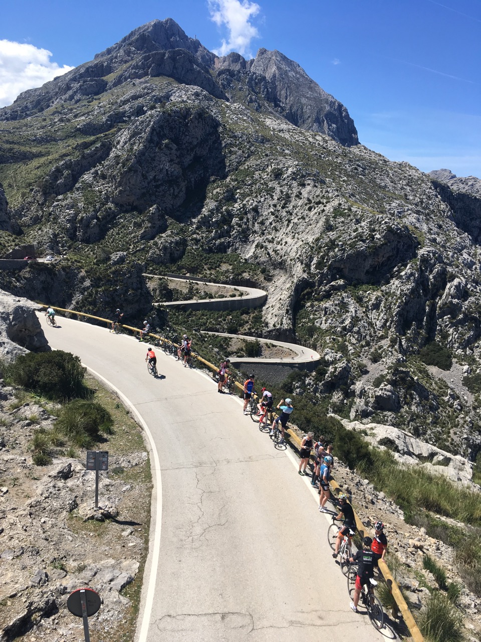
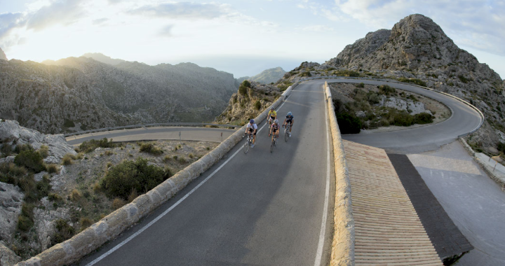
After two days to acclimate – rides of 56 miles/3.5 hours and 28/2.5 miles – our guides deemed us ready for Sa Calobra, the feared and legendary route from the Tramuntana crest to the sea. This road probably started life as a Roman goat track. Descending 687 meters (2,280’) in 9.6 km (6 miles), it rivals the climbs of cycling’s Grand Tours in length and steepness. In fact, on the unofficial website, “Top ten Craziest Switchback Cycle Climbs in the World”, it ranks #7, just ahead of the Stelvio in Italy’s Giro, and Alpe d’Huez in France’s Tour. The grade averages over 7%, hitting 14+% in many places.
The route begins at what seems to be old Roman arch. The road immediately starts a sinuous descent through a 270-degree turn back underneath the arch, and doesn’t let up from there.
Unlike modern road builders, the originators of this route simply took the terrain as they found it. Instead of cutting into the hill, they built up the roadbed with stone walls on the outside. It courses down a rocky canyon, treeless in its top half, one lane wide the whole way. This time of year, the few tourists in rental cars are vastly overwhelmed by a continuous stream of bikes. And those bikes can easily outpace the motor vehicles, scooting by through hairpin corners, hoping to avoid the bikes and cars coming back up the hill.
Fifteen to twenty minutes of coasting and braking is all it takes to reach the sea, passing from the cool breezes of 55-60 F at the top to the balmy 68-70 at the shore. About five miles down, the road makes its one concession to the terrain. A cooling cavern has been carved through the limestone bedrock, barely wide enough for the tourist buses which start coming down after noon each day.
The seaside village is Euro-quaint, all stone and cobbles, with a tiny beach sheltered in the cliffs which define the small settlement. Some of our gang, seemingly proud of the descent they’d survived, posed for a group photo – and then the REAL fun began.
Starting back up the beast, the road immediately hits 10%, and more. At least the first two miles afford some shade via the sheer rock walks and gnarly pinion pines. Arriving at the tunnel, I found a car backing out towards me. I had to stop, of course, which I knew would be problematic. At this gradient, with my wonky right knee, it might be a little tricky to get going again while remaining upright.
I quickly saw the problem – the first tourist bus of the day descending. Of course, there was no way through the crevice for both vehicles – the bus driver had to be very skilled just to keep from clipping the outboard rearview mirrors. I remounted, skirted around the still descending car, and shot through the tunnel just as the bus exited.
Behind him were scores of cyclists, half of them cursing in at least a half dozen languages, and several cars, all going at the bus’ speed, as there was no room for anyone to pass. Uphill riders had it a bit easier, as we were perforce going a bit slower, and thus took up less lateral space.
This scene repeated itself maybe twenty times more during the hour it took me to ascend The Snake. While it might have seemed scary to have those monster busses aimed right at me, I quickly realised the drivers were pros – they did this every day, and their livelihood depended on not hitting me. As long as I stayed on the fog line far right, I had, oh, maybe a foot or so of safe space between me and the meter-high wheels.
It was a grind all the way to the top. While the power numbers on my bike computer would say otherwise, it seemed like the hardest sustained mountain climb I could remember doing. For sure, it was the steadiest – my “variability index” was 1.0, meaning I was working at the same effort level for each and every pedal stroke – never a chance to ease back and rest (if I slowed my cadence, I might not start again!), and never a surge (if I tried that, I wouldn’t have enough gas to make it all the way back up).
Returning to the arch, I stopped to take in the scene. I silently vowed to return next year, with 4 more teeth on my biggest rear cog, and make it up that damned Snake in under an hour!