A week above 3000 meters, four days of hard walking, two days of rest in Lo Manthang, and we felt ready to tackle the return trip to Jomsom. It looked more primitive than the route out – no “road” to follow anywhere, just glorified goat paths, reaching a high point near 14,000’, with a scarcity of villages and tea houses. First stop: Yara, where we would stay two nights, with a day trip up the Pyung Khola gorge to view the Luri (cave) Gompa.
Already I was growing tired of the Gompas. “Don’t show me any more Gompas!” I whined to Chaim. He just gave his round Nepali grin, briefly sticking out his tongue to let me know he got the joke.
First, we had to get to Yara. It seemed simple enough…just follow the Chinese road south out of Lo, back the way we’d come, then turn left out of the Kali Gandaki into the Pyung gorge. But Chaim, who claimed to have been to Mustang “50 times” had other ideas. Before we hit the top of the windy La where Cheryl had placed her prayer flags four days ago, we headed left on one of those goat paths.
We chugged uphill a bit to the day’s high point at 4050 meters (13,300’), then cruised along a plateau for a mile or so, until we came to a small junction. Old stone foundations hugged the saddle between two sharply dropping valleys, prayer flags flying and flapping in all directions from a stake someone had secured to a corner. We had been dropping for a while, down a fairly steep slope, and were looking down an even steeper section. Waiting for us was a growing party of French-speakers, who were headed with their guide and porters up the way we’d just come.
They were aiming for Lo, and I wondered why they were taking this arduous route, so much more difficult then the gently rising road we’d followed into the walled city. My wonder turned to astonishment when a mother and crying toddler appeared over the crest. Several minutes behind them was a young woman who seemed to be taking one step every ten seconds. It didn’t seem possible she would make it to the top.
We’d had trouble enough just coming down the 25-30% slope on loose gravel. We didn’t want to fall, valuing the integrity of our hips, so each step was an exercise in stability, making sure of the purchase before taking the next, using both trekking poles for a minimum three-legged stance at all times. The toddler was continually whining and crying, ignoring her mother’s attempts at appeasement with granola and gatorade.
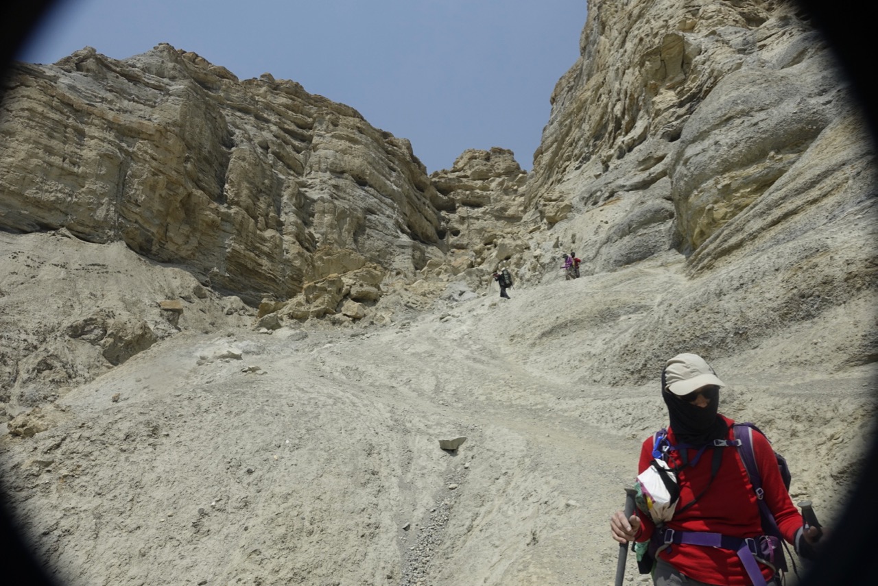
We skidded down further, reaching the top of a sheer wall of fluted spires. There seemed no way through. Coursing through the spaces between the sandy towers were chutes which resembled the start of a log flume ride. I was in the lead at this point, and had no idea where the trail went. Chaim pointed at one of the gullies, and down I went.
The wind, which was merely blowing at the top, was downright howling as I entered the slot canyon. The flutes funneled the air into the narrow space, accelerating the flow into a gale. I tightened the straps in my solar panel light cap, pulled my Buff up nearly to my eyelids, and braced myself for the dual challenge of the downhill into the wind. It was howling so, I was compelled to take a video of Cheryl and Chaim coming through the chasm.
Out the other side, things really got no better. The trail became steeper. At times, I felt like just giving up and sitting down, sliding to the bottom. The fear of (a) not being able to stop, (b) encountering a cliff, and (c) shredding my pants kept me standing and trying to walk. But it felt more like dry-land skiing than a stroll in the woods. Mostly, it was just rolling through the scree.
Looking down, we could see the oasis town of Surkhang, across the river from Dri. Up on the hillside, terraces abandoned when the irrigation stream dried up, revealed just how tenuous the hold on life is for Mustangis.
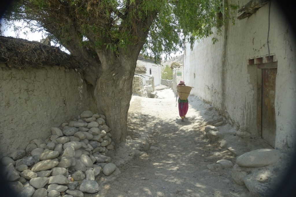 Down in Dhi (pronounced “Ghee”), narrow alleys led us to our lunch stop. Along the way, one massive cottonwood provided shade for a few pigs and a solitary yak dung hauler.
Just out of town, we crossed the Pyung Khola. Heavy treaded rock trucks simply drove right through the torrent, but trekkers used a crude bridge over the swiftly flowing freezing water. Piles of stone on each side supported two long planks, across which unevenly sized cross pieces had been nailed. No two were the same length, and the whole contraption teetered with every step.
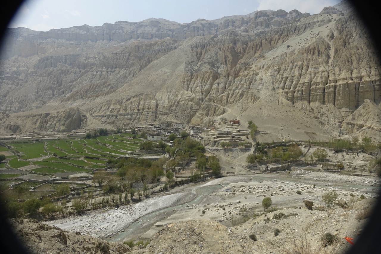
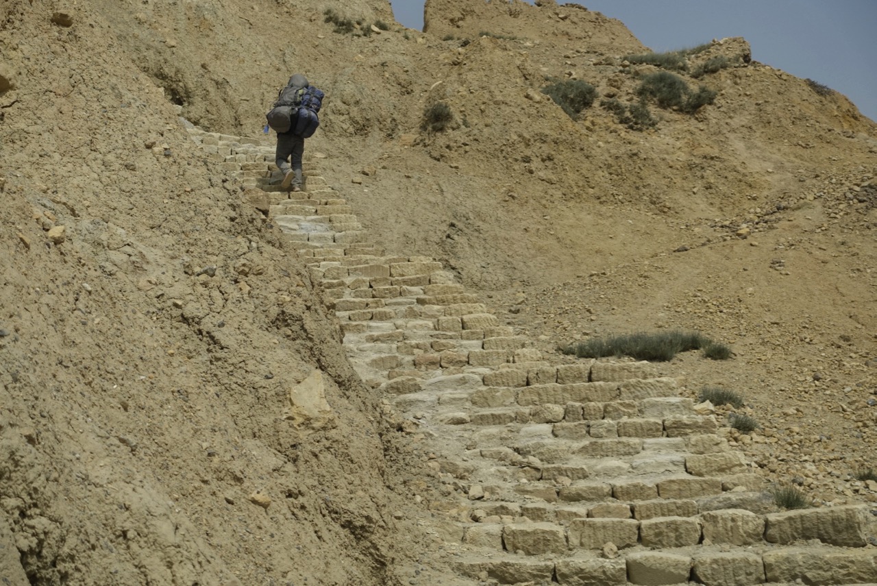
In this photo, you can trace our route down into Dhi. We crossed the saddle from Lo Manthang, in the far upper right. Then we headed down the broad smooth steeply tilted plain, heading down towards the center of the picture. There, we entered the slot canyon, emerging onto the trail aiming back to the right towards the red building on the right side of town. That is a monastery, with a large satellite dish plunked down in front of it. Then through the town, across the river on the rickety bridge, and up the hillside towards Yara. Here, the way became steeper still, necessitating a long set of stone steps to a small La, for the final descent of the day. In the very bottom right is an orange arrow. This marked the route the runners had taken two weeks earlier.
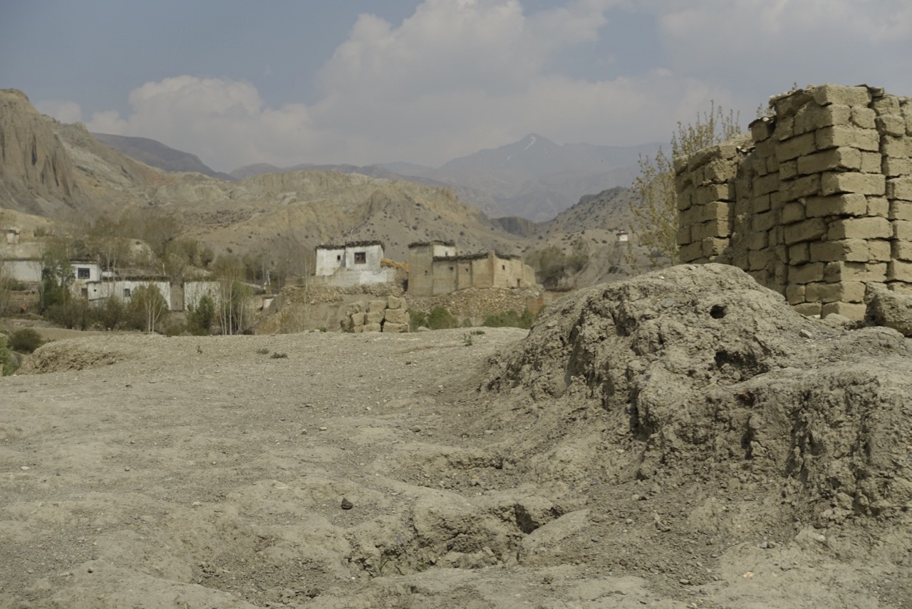
Entering town, we saw our first real clouds in a week, a harbinger of that night’s light snowfall. Stacks of adobe bricks, a sign the town was growing and needed new homes, lined the way up to our teahouse, home for the next two nights. A polyglot crew of tourists joined us that afternoon – French, German, and some really rowdy Russians. They contracted with the local Honor Man to have town folk come in after dinner for an evening of local singing and dancing, featuring Russian foot-stomping and beer slamming.