Cheryl and I left the seaside lunch stop together. On the first day of biking, I figured 56 kilometers of fast riding was enough, and spending the next 40 riding with Cheryl into the town of Guantanamo would be more fun than working hard.
Cycling heaven surrounded us; temperature around 87F, blue sky punctuated by foamy floating clouds, air softened by the sea breeze pulled inland as the day heated up. While not totally flat, the gentle rolling road never steepened into a hard climb. The only real hill came half way through, rising 300 feet in 2 miles. Looking ahead from the crest, the road ran straight for several miles to a sharp right turn in what appeared to be marshland.
Signs appeared which announced an area of heightened security. A couple of little checkpoints housed lounging soldiers, hiding from the sun on the shady side of their shack. They barely looked up as we rolled by. That right turn took us away from the northern arm of Guantanamo Bay.
Between 1868 and 1898, Cubans fought intermittently for their independence from Spain. In the final convulsion, the US became involved. We had coveted the Island for decades, even trying to buy it from the Spaniards several times. Initially, Southern politicians envisioned adding Cuba as another slave-holding state. After our Civil War, Cuba’s George Washington, Jose Marti, ignited the islanders’ own war of independence, which erupted in open battle three times over the next 30 years.
During the final episode, the Spaniards began using concentration camps to control querulous rebels. Crowded conditions there led to deaths from yellow fever and starvation. In the US, rival newspaper publishers Jospeh Pulitzer and William Randolph Hearst spouted competing headlines meant to inflame our public. In response, the US sent a war ship, the USS Maine, to Havana harbor. One night, an explosion ripped open the side of the wooden vessel, killing 260 sailors. Cries of “Remember the Maine!” screamed the headlines of papers across the US. We went to war with Spain, ostensibly to seek revenge and support Cuban independence.
By July of 1898, US troops were on Cuban soil. Col. Theodore Roosevelt led the Rough Riders calvary up San Juan Hill into Santiago, the island’s second city. Soon enough, Spain realised it no longer had the global reach necessary to sustain control of its empire half a world away in the face of rising American power. All parties went to Paris for negotiations, where Cuba was granted its independence, and the US gained control of Guam, Puerto Rico, and the Philippines. To protect out interests in the Caribbean, we were granted sovereignty over the southern half of Cuba’s Guantanamo Bay. In 1931, that control was formally recognized in perpetuity by the Cuban government, with the stipulation that no commercial enterprise be allowed there, “just” a Naval base.
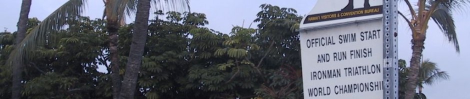
Guantanamo Bay is shaped like an hour glass. The northern, more inland half, remains part of Cuba. The town of Guantanamo sits a bit to the north of the bay itself. The US controls the southern half of the bay, with direct access to the sea, along with land on either side. On the western shore, just north of the US zone, is the village of Caimanera. It was there we planned to stay this evening, within sight of the US facilities.
Caimanera is also the location of a little known escape route for Cubans to the US. Alejandro (our guide) has family there. A few years ago, his brother and an uncle headed south, and emerged in US waters, seeking asylum. So he felt persona non grata in the area, and would not be joining us there.
Cheryl and I were not thinking about any of this as we turned away from the bay, swinging north and west towards the city. The mountains to our left had sprouted storm clouds, growing darker by the minute. It sure looked like it would rain before we got to the meeting point. As the air grew colder and moister, we speculated on what a sudden shower might feel like. We were sweating from exertion as well as the heat, and a cooling shower might be refreshing. But curtains of rain shimmered ahead of us, looking more like a gully washer than a gentle shower. We started scanning the roadside for shelter.
It soon appeared, in the form of our bus. The tandem pulled up behind us, we all stopped, and Alejandro appeared at the door. We’d gone 92 kilometers, 4 short of our goal.
“It’s time to stop. Rain.”
“Are we the last ones?” I asked.
“Everyone else is on the bus.”
Liz, the tandem stoker, announced with authority, “We’re going to quit. We don’t want to get wet.”
That did it. No way did we want to be the last ones on the road, followed by a transcontinental bus flashing its lights behind us, going 12 mph.
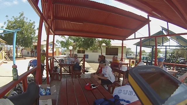
The bikes were quickly stowed inside, and within three minutes, the sky erupted. Rivers filled the road-side gullies, and we wondered where the final few riders were hiding out. We picked them up at one of the rare gas stations, at the edge of town. They’d gotten under the canopy just before the rain hit. No harm, no foul. It looked like we would get a shower and welcome cocktail with time to spare for some sightseeing before dinner. We might even get to sneak a peek into Gitmo!
First, we had to drop Alejandro off at the Hotel Guantanamo, in the center of town. He’d hide out there while we enjoyed the evening in Caimanera, 15 km around the other side of the bay.
Rain still fell as we stopped in front of the only control point we’d see on the entire island with its red and white striped barrier pulled down to block traffic. Without our ostensible translator (Alejandro) to help us, we only gradually learned we were being denied entry into Caimanera because our travel permit lacked one key signature, from the local Commandante. We would have to go back into town, try and find him, persuade him to sign, and return. At least that was one story. The other was: our group was not allowed in without a guide, and our guide was not allowed in due to his family’s transgressions. In either case, we couldn’t stay in Caimanera that night, and we had no other rooms.
Luckily, someone got the bright idea to call Alejandro at the hotel, and catch him before he’d gone out carousing for the evening. He managed to arrange lodging for us, noting that, “It’s Sunday and you wouldn’t be able to find the Commandante anyway.”
Relieved, we brightened and chattered about all the Bucaneros to be drunk that night. From the back of the bus, I noticed the streets were getting more and more narrow, and we seemed to be heading towards, not away from the bay. We were clearly lost – unthinkable, given how much we had already come to trust Juan, our bus driver, to navigate any treachery Cuban roads might serve up.
“Hey, Al! Come up here, we need your navigation!” Leader Jim was calling, and I stumbled to the front, opening up the Maps.me app as I lurched from side-to-side. Juan was holding his cell phone, and Yoany his, all while trying to drive and avoid the donkey carts, bicycles and weaving pedestrians taking up most of the alleyway.
Here’s where Maps.me really shines. It does not need a cell phone or Wi-Fi connection, using native GPS to give a pinpoint location. And because it is open source, hundreds of thousands of travelers before us had littered the map with the location of every establishment, public facility, and street name. A few “Directo”s, “Izquierdo”s, and “Derecho”s later, I had Juan driving into the spacious Hotel Guantanamo entry way. Evening salvaged; ready to try and figure out the next day’s route.